Tracking pedestrians in historic city centres
Downloads
DOI:
https://doi.org/10.7480/rius.1.198Published
Issue
Section
License
Copyright (c) 2008 Stefan van der Spek

This work is licensed under a Creative Commons Attribution 4.0 International License.
How to Cite
Abstract
This chapter describes the results of a series of pedestrian observation studies carried out in Norwich, Rouen and Koblenz as part of the Spatial Metro project. The goal of these studies was to observe pedestrian behaviour and to investigate pedestrian movement and experience in the city centres. The cities are engaged in improving the physical conditions and the experience of their city centres by investing in landscaping and engineering of public spaces, city beautification, wayfinding and in communication and information technology.
The Spatial Metro project brings together a transnational group of partners, enabling them to co-operate with a view to improving city centres for pedestrians. The theme of spatial metro is 'Discovering the city on Foot'. The project aims to make city visits more enjoyable for pedestrians by making them easier to navigate, easier to walk around and easier to understand and appreciate.
The project has been allocated European Regional Development Funding through the INTERREG IIIB Community Initiative. A group of ten organizations participate in Spatial Metro: The lead city of Norwich (UK) and the cities of Rouen (F), Koblenz (D), Bristol (UK), Biel/Bienne (CH), as well as academics from the University of East Anglia (UK), the Delft University of Technology (NL), the University of Koblenz (D) and the Swiss Pedestrian Association.
The main role of the chair of Urban Design was to develop instruments to evaluate visitor experience and to observe the use of public space. The purpose of the observation studies was to evaluate the use of space in relation to investments, (rather than using the outcome as a design tool to pinpoint) opportunities and threads in the city; the outcome focuses on a comparison between the actual situation and real use.
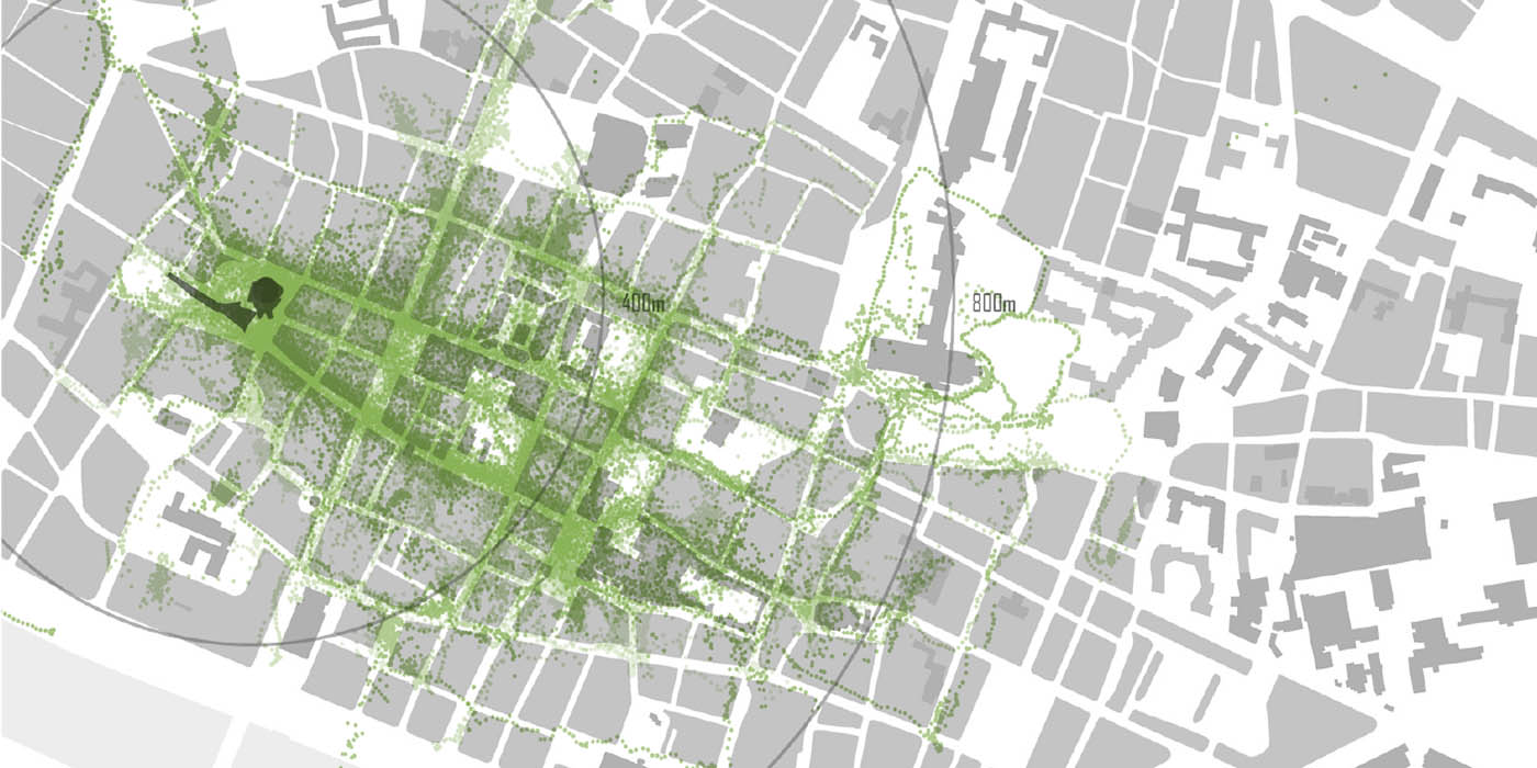
For the observation of the public space, a specific method using Global Positioning System (GPS) devices capturing the movement of pedestrians was developed and put into practice. The recording of pedestrian behaviour was accompanied by a questionnaire adding background information on the participants.
This article will focus on the differences and similarities in pedestrian behaviour in three historic cities in three countries based on quantitative and qualitative research. Do people behave different in these three historic European cities? Can we distinguish different spatial patterns based on the origin and familiarity of the visitor and the purpose and duration of the visit?
After this introduction, the set-up and implementation of the fieldwork will be explained in 'Way of Working'. Here, the methods for processing the data and the criteria employed in connection with the analysis will be clarified. Following this, the results will be described and illustrations provided for each location. The chapter concludes with a synthesis comparing the findings of the different cities.
References
Schaick, J. van (2007) Application of tracking technologies in spatial planning processes: an exploration of possibilities, RealCorp2007, Vienna.
Spek, S.C. van der (2008) Tracking pedestrians in historic city centres using GPS. In: van der Hoeven, Smit, van der Spek, eds, Street-level desires, Delft University of Technology, Urbanism, Delft.
Spek, S.S. van der (2006) Legible city - walkable city - liveable city. Observation of walking patterns in city centres, Proceedings of the Walk 21 Conference, Melbourne 2006.
Spek, S.C. van der and Schaick, J van (2007) Urbanism on Track – tracking pedestrians, Proceedings of the Walk 21 Conference, Toronto 2007.