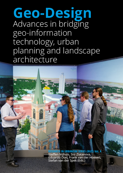
Geo-Design. Advances in bridging geo-information technology and design bring together a wide variety of contributions from authors with backgrounds in urban planning, landscape architecture, education and geo-information technology presenting the latest insights and applications of geo-design. Geo-Design is here understood as a hybridization of the concepts "Geo" – representing the modeling, analytical and visualization capacities of GIS, and "Design" – representing spatial planning and design, turning existing situations into preferred ones. Through focusing on interdisciplinary design-related concepts and applications of GIS international experts share their recent findings and provide clues for the further development of geo-design. This is important since there is still much to do. Not only in the development of geo-information technology, but especially in bridging the gap with the design-disciplines.
The uptake on using GIS is still remarkably slow among landscape architects, urban designers and planners, and when utilized it is often restricted to the basic tasks of mapmaking and data access. Knowledge development and dissemination of applications of geodesign through research, publications, and education, therefore, remain key factors. This publication draws upon the insights shared at the Geodesign Summit Europe held at Delft University of Technology in 2014. All contributions in the book are double-blind reviewed by experts in the field.
BOOK DATA
Publisher TU Delft Open // Book Editors Steffen Nijhuis, Sisi Zlatanova, Eduardo Dias, Frank van der Hoeven, Stefan van der Spek // Publication date December 2016 // Pages 284 // Full colour // ISBN 978-9492516428
Published:
2016-07-01
Editorial
-
 7-8
7-8Geodesign is a GIS-based planning and design method, which tightly couples the creation of design proposals with impact simulations informed by geographic contexts. Geodesign as such comprises a set of geo-information technology driven methods and techniques for planning built and natural environments in an integrated process, and includes project conceptualization, analysis, design specification, stakeholder participation and collaboration. Though the origins of this concept can be traced back to the early1960’s – and without computers to the end of the nineteenth century – from 2005...
Articles
-
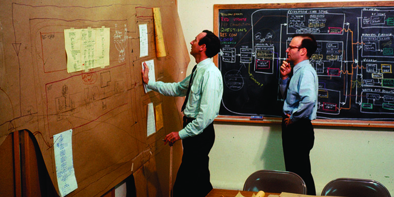
Geodesign is conceived as an iterative design method that uses stakeholder input, geospatial modeling, impact simulations, and real-time feedback to facilitate holistic designs and smart decisions. This paper aims to lay bare the beginnings of geodesign as such from 1965 onwards. It offers a personal historical perspective of Carl Steinitz, one of the protagonists in the field of geodesign. The paper describes some important milestones and influential people in a joint effort to bridge geo-information technology, spatial design and planning. It showcases the ongoing effort to employ the...
-
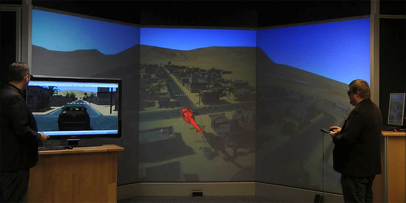
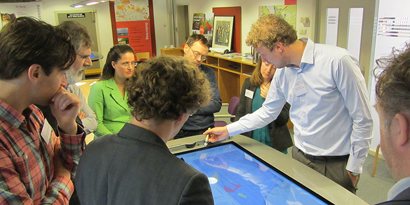
Geodesign requires the visualization of concepts and ideas within a context of geo-information of the respective place in a way that is understandable to people with different backgrounds – planners, geographers, architects, but also the users or inhabitants of the place. All of the roles involved have different requirements and need different information to fulfil their tasks within the geodesign process. In this contribution, we present the structure of a software system combining a GIS, a simulation system and a VR component, as well as interfaces to different interaction devices...
-
Despite its widespread availability there is evidence that GIS is underused in the realm of landscape design research. Though recognized as a useful tool for mapping and planning, the potential of GIS is often still underutilized due to a lack of awareness and prejudice. This paper explores some concepts of GIS-based analysis which link to the very heart of landscape architecture in a natural and intuitive way. Hence the possibility to break down barriers of using GIS in landscape architecture this paper aims to put forward some characteristic principles of study and practice that...
-
 57-70
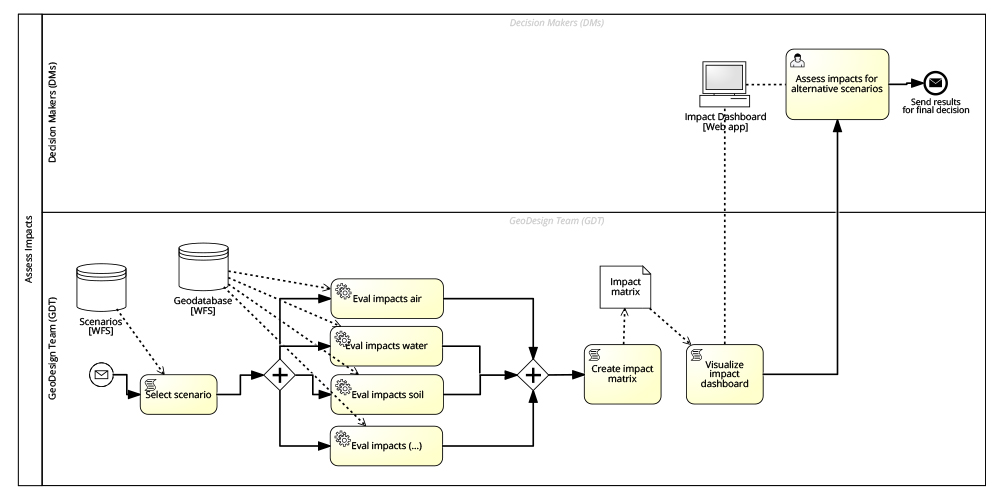
57-70This paper explores the perspective of geodesign as a process. As such, it is argued methods and tools are needed to manage the process complexity, including the definition of the involved parties, of their roles and responsibilities, as well as all the steps to be undertaken to unfold the process, together with their underlying methods and enabling technologies and tools. A metaplanning operational approach based on Business Process Management is proposed to deal with the process complexity and eventually as a means to support the construction of a second generation of process-oriented...
-
In this article we explore an expansion of geodesign to analyze processes of competition and cooperation by combining it with game-theoretical modelling and experiments. We test the applicability of facilitating these two fields in an integrated workshop by analysing the case study of oversupply of development sites in the Liemers corridor. Two workshops were held, with representatives of the six municipalities involved and with the regional and provincial authority, in which participants negotiated over the distribution of the supply of development sites. The workshops were performed...
-
 93-110
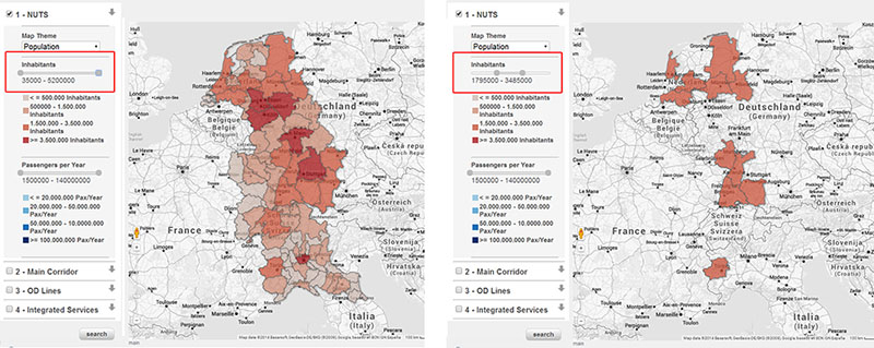
The assessment of spatial systems can be supported by the analysis of data coming from different sources and describing different aspects such as economic, social, environmental, energy, housing or mobility issues. Nevertheless, the analysis of such a large amount of data is difficult. In order to improve the readability of data also with non-technicians, new methods of communication are needed, which could facilitate the sharing of information among people with different skills and backgrounds. In this context, the paper shows the developments in geo-visualisation to support and improve...
-
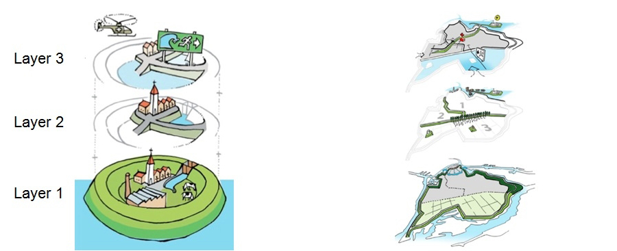
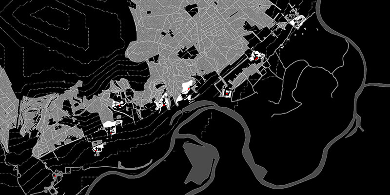
This paper aims to frame the multi-layered water safety concept in the context of a systematic, thorough, multidisciplinary and collaborative methodology for complex problems solving, i.e. geodesign. Multi-layered safety is an integrated flood risk management (FRM) concept based not only on flood probability reduction through prevention (layer 1), but also on consequences’ minimization in the case of a flood through spatial solutions (layer 2) and crisis management (layer 3). It has been introduced in the Netherlands in 2009 following the European Flood Risk Directive adopted in 2007. In...
-
 139-156
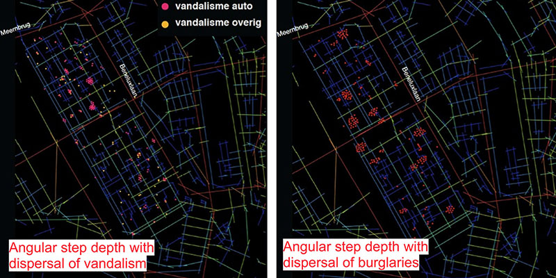
This contribution describes the tool Social Safe Urban Design (SSUD), seen together with socio-spatial and linguistic challenges when applying space syntax in the regenerating of problem urban areas. The Space Syntax jargon is technical and needs to be translated into a language understandable and acceptable to stakeholders who are responsible for the implementation of improvement strategies acceptable for the users of a neighbourhood. Moreover, the degree of public-private interface between buildings and streets needs to be incorporated in the Space Syntax analyses. As it turns out from...
-
 157-184
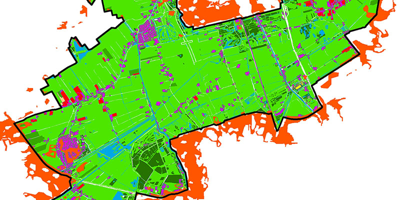
The purpose of this research is to analyse the thermal behaviour of South Holland provincial parks during heat waves, in order to provide design adaptation guidelines to increase their cooling capacity over the hotspots present in their urban surroundings. This research analyses the thermal behaviour of different land use patches (forests, cropland, grassland, water surfaces, built areas and greenhouse areas) present in the six South Holland provincial parks during heat waves. It studies their average night land surface temperature (LST) (with Modis 11A1), day LST (with Landsat 5TM),...
-
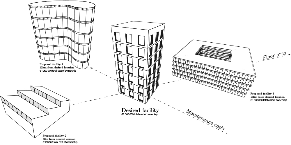
Lingering vacant facilities deteriorate the condition of an urban environment, and, as a consequence, actuate neighboring companies to leave the area as well. In addition, new development efforts keep depleting scarce land resources. In this paper, a framework is presented to match existing vacant facilities to the requirements of potential customers or owners to promote sustainable redevelopment and reuse. Important attributes for facility reuse are identified from literature. To automatically extract these attributes from models and their surroundings, Geospatial information and...
-
 Bringing Geodesign to the world in a massive, open, online engagement‘Geodesign: change your world’207-228
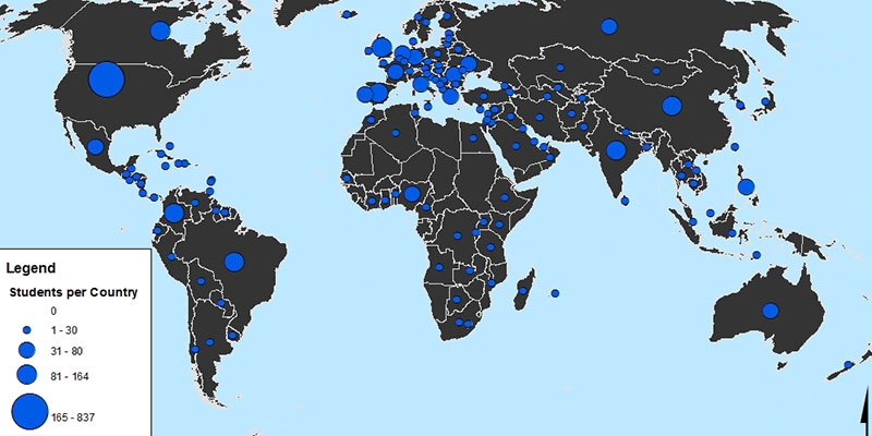
A MOOC titled “Geodesign: Change your world” demonstrated a unique approach to scaling up awareness about geodesign to a global audience. Massive Open Online Courses (MOOCs) are gaining visibility as a wide-reaching educational trend to provide exposure on topics, theories and techniques in any field. The first MOOC on the subject of geodesign was offered in Autumn 2014. Over 17,000 people registered from 167 countries. The results yielded a unique worldwide conversation about geodesign. This paper discusses how this MOOC engaged a global audience of thousands, including the challenges...
-
Geodesign provides a conceptual framework through which to understand relationships between geoscience and design. This paper takes its point of departure from the merger of the Departments of Geography and Geology and Forest, Landscape and Planning at the University of Copenhagen, and the subsequent approach taken to Geodesign as a means to realise potentials within the new academic structure. The aim is to address specifically how an on-going process of transforming the Landscape Architecture program has begun to integrate GIScience in a new way that fosters integration within and...